I have been fascinated by the history of the Three Affiliated Tribes and the Fort Berthold Reservation ever since we came to North Dakota. Fort Berthold Reservation is the closest reservation to us in North Dakota and I have been reading about its history all summer.
The Three Affiliated Tribes are the Mandan, Hidatsa and Arikara. The three tribes have similar traditions and histories. Historians say that the Mandan were the first tribe to live in the Missouri River area with the Hidatsa, and Arikara moving up the river later. Archeological evidence places the Mandan in the area around 1000 A.D. The Hidatsa moved from central Minnesota to the eastern part of North Dakota, and then to the Missouri River about 1600 A.D.
The Mandan and Hidatsa believe they were created in this area and have always lived here. According to anthropologists, the Arikara people lived in an area that extended from the Gulf of Mexico, across Kansas, Nebraska, and South Dakota. The first white people to encounter the Mandan were the French trader, Sieur de la La Verendrye, in the fall of 1738 and Charles McKenzie in 1772. They visited before the smallpox epidemic that would wipe out 90% of the tribe and cause them to join the Hidatsa further north. Lewis and Clark arrived among the Mandan and Hidatsa near Knife River in the fall of 1804.
The Mandan and Hidatsa were farmers with permanent homes in the Missouri River valley. Long before white people arrived, they lived in an almost Euro-American style. Although they moved to winter homes, their earthlodges were their permanent and ancestral homes. After the smallpox epidemic of 1837, which again decimated the tribes, they joined with the Arikara for protection against the Sioux. Although the tribes shared land, they maintained separate languages, cultures, and traditions.
The timeline and maps below are taken from the Lewis-Clark.org website.
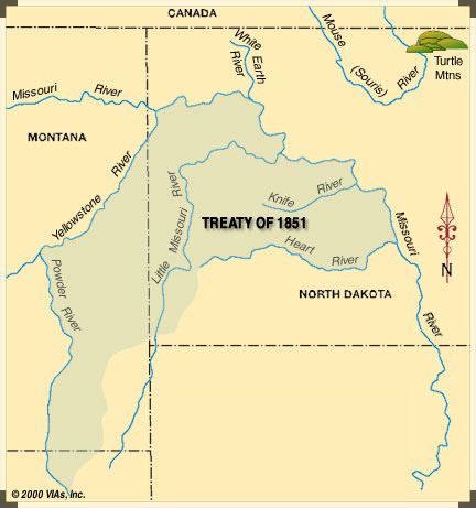
The Treaty of Fort Laramie in 1851 established the recognized land of the Three Affiliated Tribes, along with other land for six other tribes. The United States acknowledged that all the land covered by the treaty was Indian territory and did not claim any part of it. The Native Americans guaranteed safe passage for settlers on the Oregon Trail and allowed roads and forts to be built in their territories, in return for promises of an annuity in the amount of fifty thousand dollars for 50 years. The US Senate ratified the treaty, with compensation for only 10 years instead of 50.
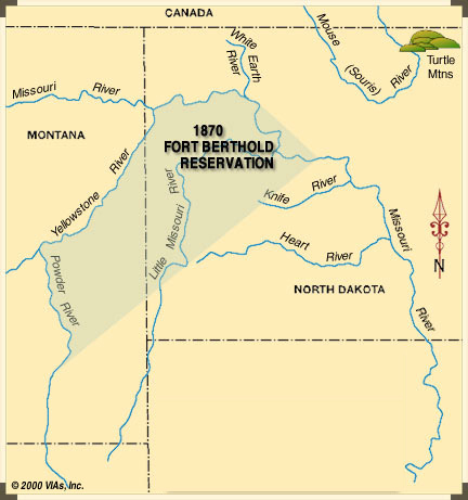
The Three Affiliated Tribes were given 12.6 million acres along the Missouri River. They settled peacefully into this area and built villages and farmed the arable land along the river. In 1870 boundaries of the Fort Berthold Reservation were established. For some reason, these boundaries did not conform to the original boundaries in the Treaty of Fort Laramie. Neither Congress nor the Indian people agreed to the change, but it was signed as an executive order. The territory of the Three Affiliated Tribes was reduced to 7.8 million acres. The tribes no longer owned the land where their ancestral villages along the Knife River had been.

In 1880 the Northern Pacific Railway needed land for its right-of-way and for white settlers to establish towns along its route. Without consulting the tribes or Congress, the US Government took away 6 million acres. The tribes were left with 3 million acres and given a little additional land north of the Missouri River. The tribes continued to farm along the river and grew wheat and other crops on 900 arable acres. They also turned to cattle ranching as a way to provide meat for the people.

Congress passed the General Allotment Act of 1887, also called the Dawes Act, which divided tribal land up into individual allotments. Each man was given 160 acres for farming or 320 acres for grazing, with some additional land for women and children. If an Indian did not accept this allotment, then he was denied American citizenship. Communal tribal lands were outlawed. The government then sold the “surplus” land to white settlers. What had formerly been a large block of land with the Native Americans allowed to go anywhere on the land, now became townships and farms with even less access for the Indians. The Three Affiliated Tribes received $800,000 for 700,000 acres of land.
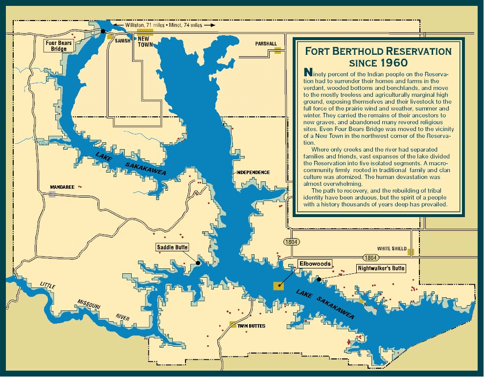
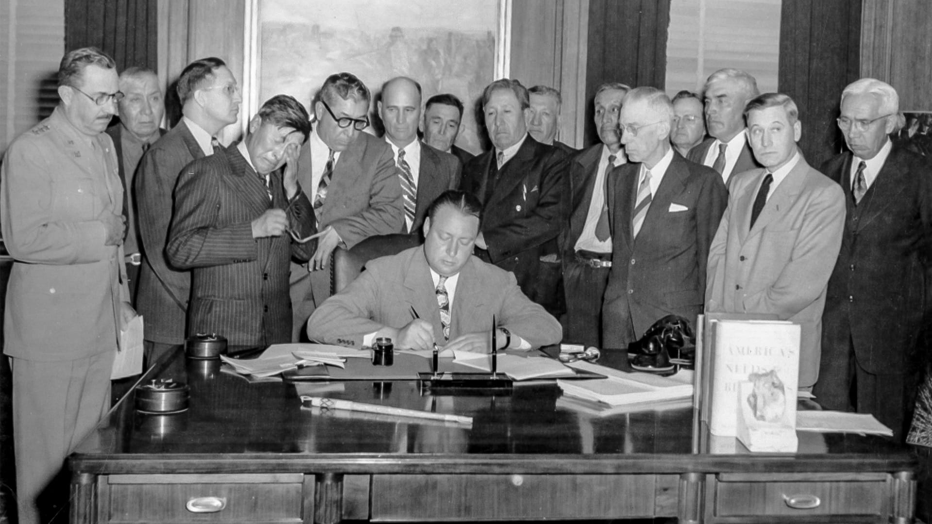
The Pick-Sloan Act, passed by Congress in 1944 was a measure to bring flood control to the Missouri River system. Along with flood control, the reservoirs and dams would provide electricity, water for irrigation, and resources for recreation. The Three Affiliated Tribes vehemently opposed the act because it took ALL of their arable land and buried it underwater. The government did not listen to them, however, and took 150,000 acres from the reservation for the reservoir. 90% of the tribal members had to surrender their homes and farmlands. Although they were given other land, it was not land in the verdant bottomland of the river valley. Instead, the tribal members were moved to land exposed to the harshest weather in North Dakota.
As compensation, the Three Affiliated Tribes were given 12.6 million dollars. The tribes fought for more money and additional benefits, such as exclusive rights to a small portion of Garrison’s hydroelectric power production at a reduced rate. These requests were denied. The final piece of settlement legislation denied their right to use the reservoir shoreline for grazing, hunting, fishing, or other purposes. It also rejected tribal requests for irrigation-development and royalty rights on all subsurface minerals within the reservoir area.
Within 5 years of the dam being built, unemployment on the reservation rose from 20 to 80%. Alcoholism and drug use soared. The tribes were no longer able to feed their people on what they could raise. Many of the tribal members sold their land because they couldn’t afford to keep it. They no longer had access to the river valley that had been their home for 1,000 years. Where only creeks and the river had separated families and friends before, vast expanses of the lake divided the Reservation into five isolated segments. A macro-community firmly rooted in traditional family and clan culture was decimated.
In 1992 the Three Affiliated Tribes won a settlement from the US Government for under-compensation in the building of the Garrison Dam. In addition to new schools, the tribes used the money to build NHS Community College in New Town. In addition, an influx of new oil money during the last 10 years has been controlled by the tribes instead of by individuals. The tribes are using that money for education, housing, and economic development on the reservation.
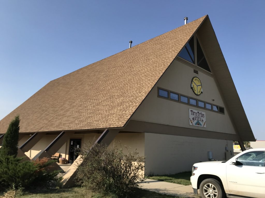
Tom and I learned all this and more when we visited two sites on the Fort Berthold Reservation. The first was the Three Affiliated Tribes Museum. We enjoyed the museum but it reminded us of a county museum where family members donate “mom’s wedding dress.” There were lots of interesting artifacts. We had a little trouble getting into the building because it was locked, but we eventually found an employee outside who told us to knock. No sign to that effect, but ok. Cost was $5 per person.
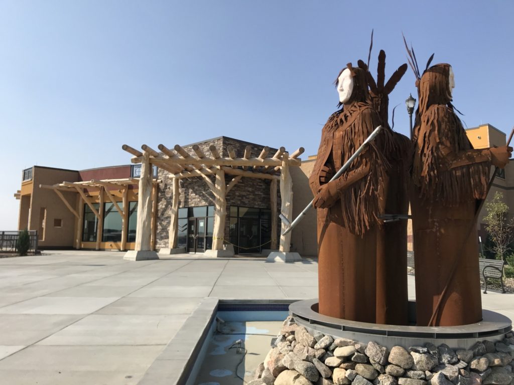
The second site was much more impressive. It was the new (opened in May) Three Affiliated Tribes Interpretive Center. The front door of the beautiful building was open, and we bought tickets to see the Interpretive Center. As we walked through the center, we followed the Missouri River on the carpeting to read and see the history of the three tribes. We learned about each tribes individual story, traditions, and language, as well as the shared history. Maps and displays took us through the timeline I described above, along with recordings of the human stories that went along with the events.
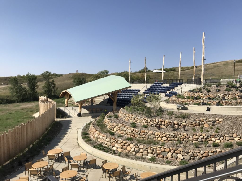
The Interpretive Center also has an outdoor amphitheater where it will present programs and plays next summer. There is a coffee house, a seasonal café, and a gift shop. Cost to get in to the Interpretive Center was $10 per person.
After leaving the Interpretive Center, Tom and I drove through New Town, the center of tribal government since the dam was built. It was a very nice town, much cleaner than most of the reservation towns we have seen. It also seemed more prosperous, so I hope things are looking up for the Three Affiliated Tribes.
Superb information. My grandparents lived in Elbowoods ND in the 1920s and early 1930s. They were employed by the BIA at Ft Berthold Indian Reservation. During their time there they were given many gifts of beautiful handmade items with intricate beadwork and quillwork : moccasins, pipebag, etc all very precious items . I am returning these items to the MHA Nation Interpretive Center and have been working with several staff members after a committee of elders reviewed photos of the items to be returned and accepted those items they identified as MHA Nation origin. I would be interested in being in contact with you more regarding our shared interest and experience.
What an interesting connection! I’m so glad you were able to add to the museum’s collection.